← All services

Vertical · Local government

Territorial decisions grounded in real data.

Your teams take decisions that shape the territory for years (high street revival, mobility, climate and energy plans, land take, utility networks), often without a fine-grained reading of the ground. GeoQriosity produces clear map diagnostics and bespoke WebGIS for people who are not GIS specialists, built on public data that already exists.

20 ans
ten of them in post, running a territorial observatory, five on assignment
WebSIG
usable without GIS skills
Street by street
SIRENE + DVF + INSEE

The observation

The debate stays general where the levers are local

01

Decisions without a close reading

Decisions that shape the territory, taken without evidence at the right scale. General impressions stand in for analysis, while the data already exists.

02

GIS that are too complex, or too frozen

QGIS and ArcGIS need a GIS specialist. A PDF delivered once does not let you follow change over time. What is missing is a simple, maintained tool that staff can actually use.

03

The time and cost of a conventional tender

A conventional GIS tender takes several months and often lands an oversized tool, with 50,000 layers and functions nobody uses day to day.

What GeoQriosity offers

Three pillars, depending on what you need

01 · Territorial diagnostics

One theme, one perimeter, one map and one note for elected officials and staff.

  • Retail vitality and vacancy
  • Housing and land
  • Mobility and access
  • Energy and climate plans
  • Land take and soil sealing
  • Facilities and public services

See the formats ↓

02 · WebGIS and working tools

A tool that stays, usable by staff with no GIS skills.

  • Processing planning applications
  • Managing water and wastewater networks
  • Roads
  • A permanent territorial observatory

Wired into your existing software, permissions by role, onboarding included.

See the formats ↓

03 · Data foundation and governance

Your public and internal data brought together, documented and automated in PostgreSQL and PostGIS, plus client-side support for your GIS specifications.

See the full catalogue →

Work delivered

WebGIS and diagnostics already delivered

A combined authority in the Paris region

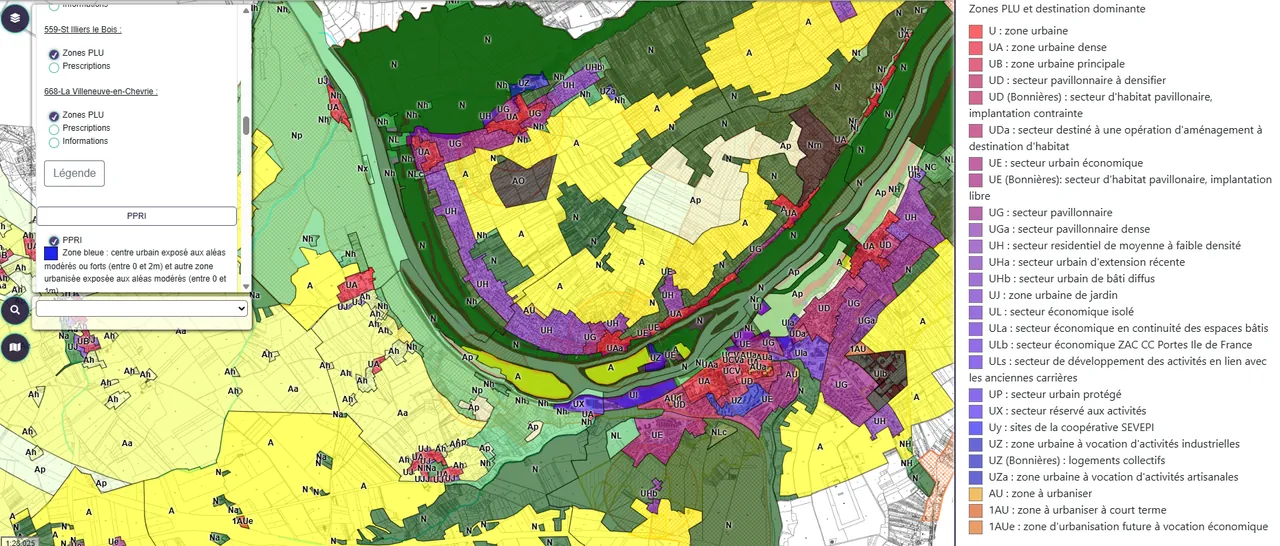
A WebGIS wired into application processing

WebGIS interface showing local plan zoning and rules across the combined authority’s municipalities

A map interface plugged into the planning application software, usable by staff with no GIS training.

Planning integrationNo GIS skills needed

A municipality in the Paris region

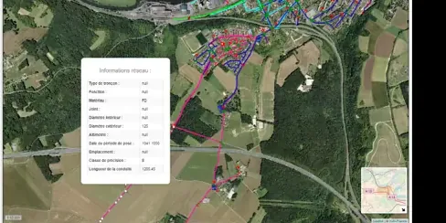
A territorial WebGIS

Municipal WebGIS interface, drinking water network layers and an information panel on one segment

Tracking territorial indicators over time, built for users in the municipal services who are not GIS specialists.

MunicipalityIndicator tracking

An urban community

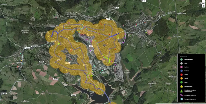
Territorial diagnostic for improving mobility

Map of the areas served by the urban transport network, buffers around the lines

Spatial analysis to improve urban transport routes and frequencies.

MobilityOptimisation

Lyon

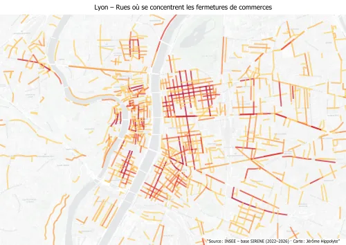
Retail fragility street by street

Map of shop closures in Lyon

The balance of shop openings and closures since 2022, by 150 m blocks and by street segment. A format that surfaces the micro-areas to deal with first.

SIRENERetail

Themes covered

The work your teams are already pushing on

Retail vitality

SIRENE + DVF + fieldwork. Identifying the streets that are slipping, the signs of vacancy, the areas to target first.

Mobility & access

Walking, cycling and public transport isochrones, poorly served areas, reachable facilities. Prioritising road investment.

Energy transition · local climate plans

Consumption by neighbourhood, energy vulnerability, renewable potential, heat networks.

Land take & land strategy

France’s net zero land take policy: brownfield sites, densification potential, historic soil sealing, support for revising the local plan.

Utility networks

Water, wastewater, roads. A management WebGIS wired into the software you already run.

Territorial observatory

A permanent dashboard: population, employment, housing, facilities. Ready to present to the governing council.

French regulatory obligations on land take and local climate plans change regularly: the framing of every diagnostic includes a check of the most up-to-date rules applying to your territory.

Why GeoQriosity

Ten years in post, five on assignment. Two readings of the same ground.

Fifteen years working for public authorities, ten of them in post as head of the territorial observatory of an urban community, five on assignment with GeoQriosity: investment decisions worth tens of millions in housing, mobility and planning, informed by multi-source territorial analysis.

I turn geospatial complexity into clear priorities for non-technical decision-makers, whether they sit in a scaling startup or in a council chamber.

Territorial observatory Data-led decisions worth tens of millions Housing & mobility Urban planning SIRENE · DVF · IGN · INSEE WebGIS delivered and running Built for non-specialists

Engagement formats

The formats for a public authority

From €1,200 excl. VAT

Territorial data framing workshop

An inventory of the data available and of the gaps, three priority use cases ranked, a summary note with an effort estimate.

From €4,000 excl. VAT

Flash diagnostic, retail and vacancy

Two maps: the balance of openings and closures by 150 m blocks, and closure density by street segment. A summary note, three priority streets with the reasoning, data delivered as GeoJSON.

From €19,000 excl. VAT

A delivered territorial observatory

A documented data foundation, a WebGIS to consult and, where needed, to edit, usable without GIS skills, dashboards set to your priorities, two half-days of training, handover documentation.

Set up on your own infrastructure or on a public cloud; hosting and maintenance priced separately.

Hosting and maintenance outside the package, no licence bought or passed on, no Esri migration.
Other formats exist for a public authority: a data foundation, an end-of-phase review, a delivered platform. See the full catalogue →

A territory that needs evidence behind it?

30 minutes to understand what is at stake and see whether a map diagnostic or a WebGIS is the right lever.

Data does not remove the risk. It lets you choose which one you take.

Book 30 min Write